
Illustrative ROI Examples
Understanding the Business Case for Drone-AI Analytics
Drone-AI analytics create value when they reduce the amount of undirected fieldwork, improve treatment targeting, shorten decision timelines, or prevent avoidable rework.
The return is different for every project. A small, accessible site may produce limited savings, while a large, remote, variable, or time-sensitive project may produce a much stronger return.
The examples below show how the business case can be evaluated across several common forestry and utility workflows.
How to Read These Examples
These are illustrative planning scenarios, not guaranteed savings or published Canopy Dynamix customer results.
Each example compares a conventional workflow with a possible drone-assisted workflow using transparent assumptions.
Unless otherwise stated, the examples use:
Loaded professional labour cost: $85 per hour
Standard field day: 8 hours
Canadian-dollar cost assumptions
Estimated drone capture and analytical costs
Continued professional field verification where required
Actual project costs will depend on area, accessibility, terrain, vegetation, flight conditions, regulatory requirements, contractor pricing, sensor requirements, and the client’s existing workflow.
ROI at a Glance
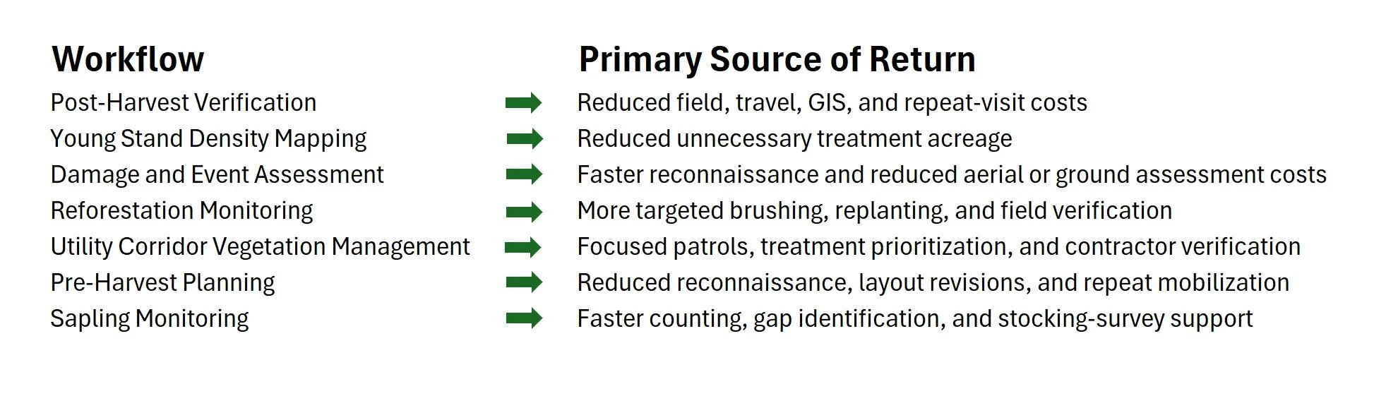
Post-Harvest Verification and Compliance Documentation
After harvesting, forestry teams may need to inspect the block, compare actual conditions with the operational plan, collect photographs and GPS information, update GIS records, and assemble closeout documentation.
A current aerial record can reduce the amount of ground that must be walked, provide a complete visual reference, and help teams identify potential exceptions before mobilizing field personnel.
Illustrative 40-Hectare Scenario →
Young Stand Density and Tending Priority Mapping
Young stands can vary substantially within the same treatment area. Sample plots may establish average conditions but provide limited information about exactly where density is high, where spacing is acceptable, and where treatment should be concentrated.
The largest potential return comes from avoiding blanket treatment across hectares that do not require intervention.
Illustrative 100-Hectare Scenario →
Damage and Event Assessment
Storms, wildfire, windthrow, pests, and drought can create urgent information gaps. The initial priority is often to determine where visible damage is concentrated, whether access is possible, and where field crews or salvage planners should go first.
The return comes from compressing the reconnaissance timeline and reducing the amount of broad ground or helicopter-based assessment.
Illustrative 200-Hectare Scenario →
Reforestation Monitoring and Free-to-Grow Screening
Reforestation programs often require repeated monitoring over several years. Field crews must assess stocking, competition, stand development, and areas that may require brushing, fill planting, or closer professional review.
Aerial screening can help teams locate likely exceptions before conducting detailed field assessments.
Illustrative 100-Hectare Scenario →
Vegetation Management Along Utility Corridors
Utilities may use combinations of aerial patrols, ground inspections, contractor reports, GIS records, and recurring vegetation-maintenance programs.
Drone-AI analytics can create a continuous corridor record and help direct field verification and treatment toward locations with visible vegetation concerns.
Illustrative 100-Kilometre Corridor Scenario →
Pre-Harvest Planning and Operational Layout Support
Pre-harvest planning commonly combines desktop mapping, existing imagery, field reconnaissance, GPS layout, access review, GIS revision, and professional assessment.
Current aerial imagery can help identify visible conditions and potential constraints before field crews begin detailed layout.
Illustrative 150-Hectare Scenario →
Sapling Monitoring and Stocking Survey Support
Early regeneration monitoring often requires crews to travel between sample plots, count visible seedlings, identify gaps, and compile the results into stocking and follow-up recommendations.
Drone-AI analytics can accelerate counting and provide a broader spatial view of visible sapling density and regeneration patterns.